WISPDRONE.CO
  • Home
    • About Us
    • Contact
    • Case Study
    • FAQ
    • MIssion
    • News
    • RMA
    • Shipping
    • Sponsor
    • Store
    • Terms and Conditions
  • WISP DRONE
    • WHICH DRONE? >
      • WISP DRONE
      • TAROT DRONE
      • iBOT DRONE
    • Compare Drones
    • Drone Showcase
    • Checklist
    • Flight Planning
    • Getting Started
    • SHOWCASE
    • Order
    • WISP Drone Daily
  • Air Surveyor
    • AIR SURVEY DRONE
    • AirSuveryor GDM
    • Carriage Showcase
    • EZ Drone Drop
    • Hango
    • ShowCase
  • Courses
    • Conference
    • Meetups
    • Podcast
    • Training
  • DIY
    • Assembly >
      • WISP Drone
      • Tarot ZD850 Assembly
      • Tarot 690 Assembly
      • Quad Copter Drone
      • PixHawk
      • Connecting Raspberry Pi w/ Pixhawk
    • Drone Site Survey
    • Site Survey Carriage
    • Apps
    • Tracker
    • Cloud
  • Support
    • Blog
    • Calibration
    • Checklist
    • Code
    • Documents
    • Videos >
      • Drones
      • PROMO
      • PROMO2
      • Mapping
Picture

SOFTWARE / APPS / WEBSITES 


Picture

This software is for connecting to your WISP DRONE, and doing a site survey from your cell phone or tablet.

​All software comes with no warranty.

Contact us of you need any help

Home of the perfect site survey !


EasyUbnt Lite
EASY UBNT

$free

android app

$8

per app install

Absolute must for wireless ISP providers running network on Ubiquiti Networks gear! EasyUbnt can connect to any device with AirOS 3/4/5 operating system (Nanostation, PowerStation, Nanobridge, Airgrid, Rocket, Bullet, Picostation, Powerbridge, ..) and setup them completely from your Android device. No need to take your laptop with you anymore.

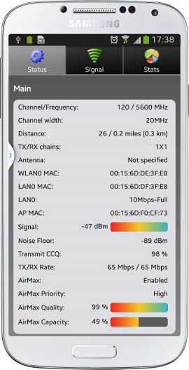
Moreover it has some professional and unique features which are not in the AirOS web interface. You can try ubnt device discovery tool, online speedtest (shows instantaneous device speed), voice signal navigation, continuous site survey, encryption key database for your whole network and many other unique tools for wireless professionals!

This version was tested on AirOS 5.
airOS Mobile

$free

android beta


airOS Mobile application is a tool for managing airMAX devices. It features status monitoring, offline firmware upgrades, antenna alignment and device installation using any Android smartphone.

Communication with device is done solely through HTTP(S) and access to devices on these ports is required.
Application layout is optimized for smartphone screens but will work on tablets too.
​
Install using airGateway Installer is supported for AC series devices only (starting with airOS v7.2)
Features
  • Easy device installation using airGateway Installer
  • Support for airOS v5.5.6 and up
  • Offline firmware upgrade from Android device
  • Configuration backup and sharing
  • Device discovery
  • Site Survey tool with result export to CSV
  • Antenna alignment tool with audio feedback
UMobile

$ free


The UMobile™ app is a convenient client application for installing Ubiquiti Networks® airMAX® devices. It features device discovery, site survey, airMAX AC device installation using the airGateway™ Pro Installer, provisioning with configuration templates, antenna alignment, configuration backup and sharing, and offline firmware upgrades.The UMobile app communicates with airMAX devices over HTTP(S), so the UMobile app requires access to the devices on these ports.
Minimum Firmware Requirements
airMAX AC devices: version 7.2.0 or higher
airMAX M devices: version 5.6.5 or higher
airGateway devices: version 1.1.7 or higher

SITE SURVEY TOOLS

Tower Coverage
Paid / Free Demo Account
$PAY
Longitude & Latitude
FREE
NO CHARGE
HEY WHATS THAT
Free / No Cost , Ever
​$FREE
Our simple to use system will allow you to create Tower Coverage Maps for any geographical area in the entire world. Our maps are based on actual RF propagation, topography, and land cover data. Maps can be created for nearly every frequency range.
Picture

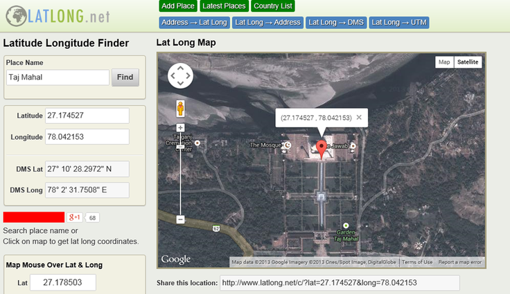
To make a search, use the name of a place, city, state, or address, or click the location on the map to find lat long coordinates.

Hey Whats That  is an amazing website for free site survey information and more.

Free Path Profiler
Free RF Mapping
FREE WISP Tools 
Absolutely a must for every WISP !
Powered by Create your own unique website with customizable templates.
  • Home
    • About Us
    • Contact
    • Case Study
    • FAQ
    • MIssion
    • News
    • RMA
    • Shipping
    • Sponsor
    • Store
    • Terms and Conditions
  • WISP DRONE
    • WHICH DRONE? >
      • WISP DRONE
      • TAROT DRONE
      • iBOT DRONE
    • Compare Drones
    • Drone Showcase
    • Checklist
    • Flight Planning
    • Getting Started
    • SHOWCASE
    • Order
    • WISP Drone Daily
  • Air Surveyor
    • AIR SURVEY DRONE
    • AirSuveryor GDM
    • Carriage Showcase
    • EZ Drone Drop
    • Hango
    • ShowCase
  • Courses
    • Conference
    • Meetups
    • Podcast
    • Training
  • DIY
    • Assembly >
      • WISP Drone
      • Tarot ZD850 Assembly
      • Tarot 690 Assembly
      • Quad Copter Drone
      • PixHawk
      • Connecting Raspberry Pi w/ Pixhawk
    • Drone Site Survey
    • Site Survey Carriage
    • Apps
    • Tracker
    • Cloud
  • Support
    • Blog
    • Calibration
    • Checklist
    • Code
    • Documents
    • Videos >
      • Drones
      • PROMO
      • PROMO2
      • Mapping