WISPDRONE.CO
  • Home
    • About Us
    • Contact
    • Case Study
    • FAQ
    • MIssion
    • News
    • RMA
    • Shipping
    • Sponsor
    • Store
    • Terms and Conditions
  • WISP DRONE
    • WHICH DRONE? >
      • WISP DRONE
      • TAROT DRONE
      • iBOT DRONE
    • Compare Drones
    • Drone Showcase
    • Checklist
    • Flight Planning
    • Getting Started
    • SHOWCASE
    • Order
    • WISP Drone Daily
  • Air Surveyor
    • AIR SURVEY DRONE
    • AirSuveryor GDM
    • Carriage Showcase
    • EZ Drone Drop
    • Hango
    • ShowCase
  • Courses
    • Conference
    • Meetups
    • Podcast
    • Training
  • DIY
    • Assembly >
      • WISP Drone
      • Tarot ZD850 Assembly
      • Tarot 690 Assembly
      • Quad Copter Drone
      • PixHawk
      • Connecting Raspberry Pi w/ Pixhawk
    • Drone Site Survey
    • Site Survey Carriage
    • Apps
    • Tracker
    • Cloud
  • Support
    • Blog
    • Calibration
    • Checklist
    • Code
    • Documents
    • Videos >
      • Drones
      • PROMO
      • PROMO2
      • Mapping

AIR SURVEYOR

GDM 2.0 

DRONE 3D imaging software
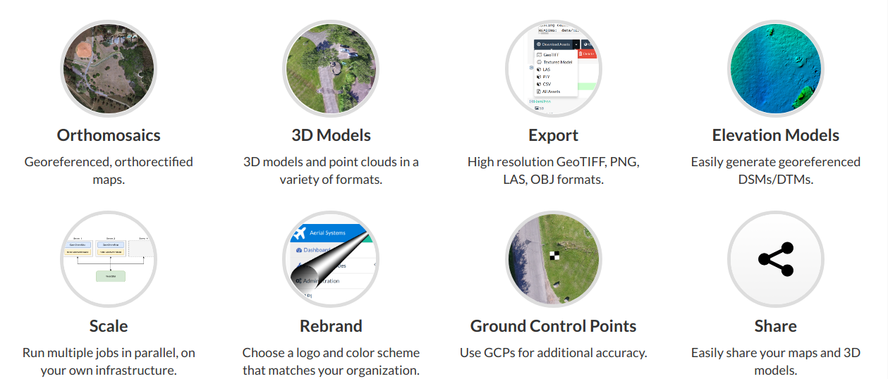
User-friendly, extendable application and API for drone image processing. Generate geo-referenced maps, point clouds, elevation models and textured 3D models from aerial images.

Picture
New Features:

  • 2.5 dimensional mesh
  • Create georef transformation file
  • DEM/DTM modeling with ground classification
  • Add python contributions/plugin support
    • vegetation indices
    • blender
    • video 360
  • Fast orthophoto with sparse reconstruction
  • Add ID column support for GCP files
  • Expose more parameters for OpenSfM (depth map, etc)
  • Add support for laz output

Fixes/updates:
​
  • Updated PDAL pipeline and version
  • Increase useful output to stdout
  • Remove resizing of original images (fixes issue with georeferencing
  • Fix GPS altitude tag parsing
  • Pyexiv2 crashing issue
  • Fix x,y dimensions in exif after resize
  • Improve install/configure script
  • Improve usability
  • improve readme instructions
  • remove depreciated parameters
  • Update dependencies
  • improve docker usability
  • fix utm bug: OpenDroneMap/WebODM#267
  • replace jhead with exiv2
  • fix end_with tag with mvs-texturing
  • add ability to skip convert_to_las
  • fix issue with single-digit utm zones
  • Handle bundler files that have invalid/empty camera parameters
  • remove sudo statements from config
  • Fixed single-material rendering bug in odm_orthophoto
  • Split-merge, for very large datasets
  • Improve GDAL memory management
  • Presever double coordinates precision in odm_georef
  • Fix GCP accuracy issues
  • odm_georef output to binary instead of ply
  • fix mvs-tex temp dir issues
  • make csv export optional
  • improve odm_georef processing speed
  • use cmake build type for internal modules
  • remove mesh command in opensfm (currently unused)
  • fix gippy download
  • fix build processes in config script
  • Fix VTK build
Picture

    GDM Signup 

Submit
Powered by Create your own unique website with customizable templates.
  • Home
    • About Us
    • Contact
    • Case Study
    • FAQ
    • MIssion
    • News
    • RMA
    • Shipping
    • Sponsor
    • Store
    • Terms and Conditions
  • WISP DRONE
    • WHICH DRONE? >
      • WISP DRONE
      • TAROT DRONE
      • iBOT DRONE
    • Compare Drones
    • Drone Showcase
    • Checklist
    • Flight Planning
    • Getting Started
    • SHOWCASE
    • Order
    • WISP Drone Daily
  • Air Surveyor
    • AIR SURVEY DRONE
    • AirSuveryor GDM
    • Carriage Showcase
    • EZ Drone Drop
    • Hango
    • ShowCase
  • Courses
    • Conference
    • Meetups
    • Podcast
    • Training
  • DIY
    • Assembly >
      • WISP Drone
      • Tarot ZD850 Assembly
      • Tarot 690 Assembly
      • Quad Copter Drone
      • PixHawk
      • Connecting Raspberry Pi w/ Pixhawk
    • Drone Site Survey
    • Site Survey Carriage
    • Apps
    • Tracker
    • Cloud
  • Support
    • Blog
    • Calibration
    • Checklist
    • Code
    • Documents
    • Videos >
      • Drones
      • PROMO
      • PROMO2
      • Mapping